Basic Layout of the TRIANGLE with main street names and abbreviations.
(see Latest News) - for location and times (the exhibition is continuing until the 19th June at the National Sports Centre - but , evidently, without attendents to answer questions)
What follows here is the text of their Transport Projects Exhibition giving you another opportunity to consider the full import of these sweeping changes.
If you don't like what you read telephone:
Geoff Dadd at Bromley Council on 020 - 8464 3333 and
write to him at
Bromley Civic Centre, Stockwell Close, Bromley BR1 3UH
with a copy to
John Prescott, House of Commons, SW1A 0AA.
John Payne (Press Officer of the Crystal Palace Campaign): "Most of this is to facilitate that top site development. Why am I going to pay for parking?"
Buchanan: "Well, it's to maintain the system."
JP: "Why aren't the developers paying for the parking?"
B: "It's because it's not directly related to the development."
JP: "Yes it is. Of course it is. None of this was happening until
this top site development came along. Take that element out of the
equation - a whole different ball game. I'm not saying that we don't
need some parking issues addressed and some traffic issues. We do.
But not to the level we're talking about. We're talking about 17,000
vehicle movements on a Saturday alone, without the rest of the week.
Of course you've taken that into these equations. Take those 17,000
out and you'll have a different set of equations. Most of this is
purely and simply to fascilitate that top site development to which
evryone is opposed, - very few exceptions."
WELCOME - Board 1
The Crystal Palace Partnership brings together four London boroughs, Bromley, Croydon, Lambeth and Southwark and many other partners to push forward the regeneration of the Crystal Palace area. The regeneration programme includes over 40 projects that support local businesses, provide jobs and training and improve the environment. It is funded by £14m (m=million) of Single Regeneration Budget (SRB) money and over £140m of public and private sector investments.
Transport Projects Exhibition
Transport is an important part of the overall regeneration strategy. £5.5m has been allocated to improve transport across the area. The Crystal Palace Partnership together with the London Borough of Lewisham and London Transport is now looking at the options to best use this money. This exhibition is designed to gather your views on the issues and options before decisions are made.
YOUR GUIDE - Board 2
The Crystal Palace Partnership has commissioned a series of studies to address transport issues in the area. The exhibition is in sections corresponding to each topic. Please take a look at the introduction boards and then select the projects and localities that interest you.Take your time, come back for more later if you like!
Staff are on hand to help you. Please feel free to ask whatever questions arise.
Questionnaire
We want your views. Do spend a few minutes to complete your exhibition questionnaire. Fill it in as you go around.
CRYSTAL PALACE REGENERATION - Board 3
Park Projects
The regeneration programme is centred on four major projects to restore Crystal Palace Park to London-wide prominence.
WIDER PROGRAMME - Board 4
The other 40 regeneration projects aim to ensure that local residents and businesses benefit from the Park projects.
The projects will:
PUBLIC TRANSPORT - Board 5
Policy Objectives
The Partnership's transport objectives are:
High quality public transport is central to achieving the objectives. There will be no new main roads in South London - all plans have been scrapped for several years now. Instead we must make the most efficient use of the roadspace available. The Partnership is asking car owners to use their cars less and to use the alternatives more - public transport, and walking or cycling for shorter trips. In return we are committed to improving those alternatives.
Public Transport Hub
The Partnership's prime transport scheme is the development of Crystal Palace as a public transport hub. Two key projects are the development of a bus-rail interchange at Crystal Palace Station and of a new bus station on Crystal Palace Park.
Bus Study
The Government wants to transform the bus from a workhorse to a thoroughbred. The Partnership commissioned the Bus Priority, Access and Service Quality Study to investigate how SRB money can help. The consultants have looked at bus improvements under five headings:
Tramlink Extension Study
The Croydon Tramlink system opens later this year and will reach Elmers End and Beckenham Junction. The Tramlink Extension Study looks at options for a future spur to Crystal Palace.
PUBLIC TRANSPORT - Board 6
The Network
Crystal Palace is already highly accessible by public transport. 13 bus routes run from Crystal Palace Parade with over 1000 departures per day, whilst 8 trains per hour from Crystal Palace Station serve over 25 destinations. These services carry around 15,000 bus and 2,300 train passenger trips per day to and from Crystal Palace.
This is a strong starting point. However, there remain gaps in the coverage of the network. Integration between bus and rail travel needs to be much improved.
Does the existing network of bus and train services meet your needs? We need your views.
The bus and rail network is extensive but complicated. The Crystal Palace Partnership and London Transport have agreed to include Crystal Palace in the programme to introduce simpler 'tube-style' bus maps.
Information and marketting
New bus routes?
Quick east-west movement across South London is a key missing link in
the public transport system. Crystal Palace Partnership will lobby
for this as part of any new network initiative.
CRYSTAL PALACE HUB - Board 7
New Bus/Rail Interchange
It is vital to better integrate bus and rail travel. We propose three options for allowing bus services to serve Crystal Palace Station directly and give interchanging passengers a more seamless journey. Ideally as many bus services as possible would serve Crystal Palace Station but room for buses is constrained. If there is room to extend two services to the station the 249 to Streatham and the 63 to Peckham are suggested.
What are your views on:
Parade Terminus
Plans are well advanced to build a new bus terminus on Crystal Palace Parade. This will improve waiting and interchanging facilities for bus passengers, it will also remove parked buses from the street allowing bus lanes to be introduced. New crossings will allow safer crossing of the Parade.
Three maps of the Crystal Palace Station / Ledrington Road area giving three options for a bus turnaround area.
BUS SERVICE QUALITY - Board 8
Newer buses, improved services
London Transport Buses will be introducing new high quality, low floor buses over the coming years on all routes serving Crystal Palace. London Transport is also dedicated to continuous improvement of the frequency and hours of operation of bus services.
Getting to the bus
The ride is only part of the trip by bus. We want to upgrade facilities for getting to the bus to match improvements in the buses themselves. This means:
Bus Stops
A full inventory of bus stop facilities throughout the area has been made. This will enable us to target improvements where they are most needed. We aim to provide:
Other bus-rail interchanges
The diagram shows key interchange points for accessing the other train services in the Crystal Palace area. Locations where bus-rail interchange facilities could be improved and promoted as shown. Penge East and Penge West stations have recently been improved with further works planned.
BUS PRIORITY - Board 9
We aim to give buses priority on roads to Crystal Palace. Bus lanes are an effective way of improving bus journey times and reliability. This benefits bus passengers and should also encourage people to use buses instead of the car.Motorists must respect bus lanes and keep them clear from obstruction, or else they will not work effectively.
Enforcement of the bus lane regulations, by Council wardens working in partnership with the Police, is an important part of the plan. We propose dual use CCTV cameras which, as well as assisting bus lane enforcement, would improve personal security and deter crime.
New bus lanes and other improvements proposed around the area are shown on the plan in red. The bus lanes will generally replace existing centre hatching parking and cycle lanes (cyclists will be allowed to use the bus lane) and will therefore not reduce traffic capacity. Parking, however, will have to be restricted in order to keep the bus and traffic lanes free from obstruction.
We would like your views on the following proposals.
1. Anerley Road - A new bus lane towards the Robin Hood junction (between Maple Road and the bus stop just west of Croydon Road) would assist buses on routes 157, 351 and 358.2. Westwood Hill - Buses on routes 122 and 450 currently suffer from congestion on the approach to Sydenham. Widening of Westwood Hill east of Lawrie park Avenue to provide an eastbound bus lane would help. Some footway parking would be lost, but most would still be accommodated, and overnight parking would be allowed within the bus lane.
3. Elder Road / Central Hill - To improve road safety, it is proposed to signalise this junction. This would provide pedestrians with ëgreen man' crossings, and cyclist with cycle lanes and advance stop lines.
BUS PRIORITY PROPOSALS - Board 10
4. Sydenham Hill bus lane - A southbound bus lane in Sydenham Hill towards Crystal Palace would assist buses on routes 202 and 63 (to be replaced by new route P10). The proposed lane would allow buses to by-pass traffic queues up to the junction with Westwood Hill. Speed reduction measures further north on Sydenham hill are shown in the ëTraffic Calming' boards.
5. Sydenham Rise - There is insufficient road width for a bus lane at the northern end of Sydenham Hill on the approach to the South Circular Road. If northbound buses on route 63 were diverted via Sydenham Rise, a northbound bus lane on Sydenham Rise would help buses on both route 63 and route 352. The bus lane would require either the loss of parking on the eastern side of the road, or alternatively making Sydenham Rise one-way.
6. Crystal Palace Park Road / Westwood Hill junction - Signalising this junction would:
- enable a new pedestrian crossing to be provided across Westwood Hill.
- prevent the busy right turn from Westwood Hill into Crystal Palace Park Road from extending back and blocking other traffic.
It is also proposed to extend the hours of the existing west bound bus lane towards Westwood Hill to operate peak and Saturdays as well as the week day morning peak. This would further assist route 227.
Bus Stop improvements
Bus stop improvements are proposed at Kent House and Clock House Stations and along Anerley Road. The schemes are exhibited within the traffic calming proposals.
Your views: we want to hear your views on these proposals.
JUNCTIONS - Board 11
The roads and junctions around Crystal Palace Park have been studied with the intention of achieving
Anerley Hill, Westow Hill, Crystal Palace Parade, Church Road junction.
The final design for this junction will depend on the preferred option for the Upper Norwood Triangle (see the Triangle Boards). However, the existing roundabout is already unable to cope with the traffic flows in the area at peak times and there is severe congestion. A new signalled junction is proposed to replace the existing roundabout so that
Anerley Hill Bus Lane
A short length of bus lane is proposed westbound on Anerley Hill. There will be more buses along Anerley Hill with the proposed station interchange.
New Crystal Palace Site Access
A new signalled junction will be provided at the Anerley Hill entrance to the new Crystal Palace. A ëgreen man' crossing of the access road is proposed.
Crystal Palace Park - National Sports Centre entrance
A new signalled junction is proposed to improve safety at the Park entrance. New green man crossings are proposed.
Crystal Palace Station
Depending on the preferred option for the improved interchange between bus and rail at Crystal Palace Station, a new signalled junction may be required, as illustrated. In any option, it is proposed to improve the pedestrian crossing across Anerley Hill and to relocate the westbound stop closer to the station and the crossing.
Walking routes to the station
Whichever station interchange option is preferred we propose to improve the walking route between the railway station and Crystal Palace Parade.
CRYSTAL PALACE PARADE - Board 12
It is proposed to redesign the whole length of Crystal Palace Parade.
Crystal Palace Parade/Fountain Drive/Sydenham Hill/Westwood Hill
A new signalled junction is being considered to replace the existing pair of roundabouts. The proposed junction layout would:
In order to achieve these benefits it would be necessary to ban three of the lesser used turning movements (cyclists would be exempt):
Access to the new Crystal Palace/Parade/College Road
To allow vehicles to safely enter and leave the new Crystal Palace, a new signalled junction with "green man" pedestrian crossings will be built on the Parade next to the College Road junction. In addition to minor widening is proposed to provide an extra lane at the exit of College Road.
Pedestrian Routes
Bus lanes
Bus lanes are proposed in both directions along the Parade to give buses priority.
Your Views
We want to hear your views on the junction and street layout
proposals.
Tramlink Extension Study
THE STUDY - Board 13
Tramlink is currently in the final stages of construction, with tram services scheduled to start running in November of this year. The Crystal Palace Partnership want to see if an extension of Tramlink to the Palace would provide an alternative to increasing car use in the area. Consultants were asked to study the opportunities in the area to see if such an extension would be possible. An essential requirement of the study was that any such proposed routes should link Crystal Palace Terminus with the new Bus Station on the Parade.
The study examined all possible ways of linking Tamlink to the Crystal Palace area.
The "Long List"
The initial examination produced an options "long list". These were tested against a number of criteria:
UPPER NORWOOD TRIANGLE - Board 15
Study Objective - to promote as part of the regeneration programme for the Crystal Palace area the prosperity of Upper Norwood and enhance it as a district centre by means of a comprehensive package of environmental and transportation proposals developed in consultation with local residents and business.
Background
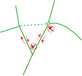
The Triangle is formed from three roads: Westow Hill, Westow Street and Church Road. Its position on the old boundary between the counties of London, Surrey and Kent is reflected in today's situation, whereby the Triangle lies within the three London Boroughs of Croydon, Lambeth and Bromley.
The Triangle is a classic London "urban village". Its strength lies in the way a great variety of people and activities are brought together into a small area. It is a traditional district centre serving local people for shopping and community facilities. It is also increasingly becoming a centre for dining out and independent niche shopping. The Triangle has a diversity of homes and premises for small businesses. The urban village is popular with all and generates a fierce community pride and active civic participation. However, changing shopping habits together with the environmental problems created by traffic have contributed to decline and the attendant problems of vacant shops and premises in great need of repair.
Conservation Area Partnership
The Triangle has an important heritage and many listed buildings. The need to protect and enhance it's heritage has been recognised by the declaration of conservation areas and the joint three borough / English Heritage Conservation Area Partnership scheme (CAPS). CAPS will:
In addition, over £300,000 is available through the CAPS programme for structural repairs, restoration of lost detail and shop front improvements to buildings in the Triangle.
Upper Norwood Triangle
ISSUES AND VISION - Board 16
The Triangle's traffic problems are also typical of a London urban village. Its premises have inadequate rear access and its roads are narrow such that they just cannot cope with high traffic levels. Yet Church Road and Westow Hill remain 'A' roads, locally crucial routes for through movement serving bus passengers and deliveries as well as the private car. The public workshop organised by Croydon Council in September 1998 confirmed local people's concerns and aspirations for the area. In short, improvement of the street environment has two important and inter-related elements:
1. Traffic management and road space re-allocation to resolve, more efficiently, the often conflicting needs of:
2. Environmental improvements, where possible taking advantage of the opportunities offered by the traffic management schemes from (1):
Existing Travel To and From the Area
The London Area Travel Survey shows that over 30,000 person trips are made to and from the ward of Upper Norwood per day (7 am to 10 pm).
The modes of transport are as follows:
A PLACE FOR PEOPLE - Board 17
Pictures
STREETSCAPE - Board 18
Pictures of Street Furniture and Tree Species
TRAFFIC OPTIONS - Board 19
(Options "long list")
The opportunities in the Triangle are largely governed by the arrangement adopted for traffic circulation. But we must remember that changes in the Triangle could easily have an impact on traffic conditions over a much wider area.
|
|
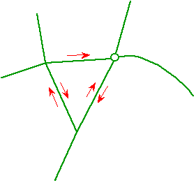
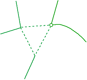
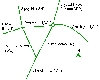
Basic Layout of the TRIANGLE with main street names and abbreviations. |
The consultants considered the full range of possibilities and tested a long list of seven traffic options.
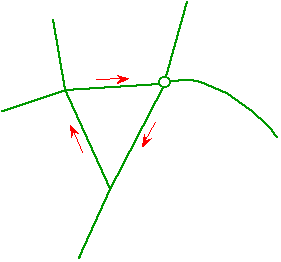
1. Do nothing in the Triangle (Do Minimum);This option would leave traffic circulation and junction control in the Triangle as it is. This and all the other options were tested with the forecast levels of traffic on Friday evening (6-7pm) after the new Crystal Palace has opened.
PROS: no construction work; cheap
CONS: worse congestion; poor crossing facility ; no pavement widening[Basic layout - unchanged - see map above]
2. One-way Westow Hill
Westow Hill has the most pedestrians and the worst traffic congestion of the Triangle's streets. This option aimed to allow better servicing arrangements and wider pavements on Westow Hill.
PROS: opportunities to improve Westow Hill
CONS: worse congestion particularly on Westow Hill and Church Road3. One-way Triangle
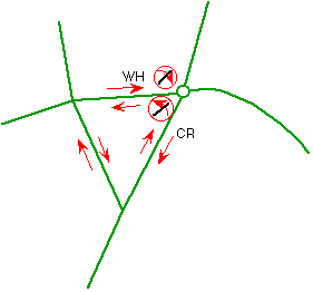
A clockwise one-way system around the Triangle. This would allow wider pavements and/or new parking/loading bays on all three streets. Fewer conflicting movements at the junctions allow new pedestrian crossings to be introduced at each corner of the Triangle. NB Long vehicles cannot turn right into Church Road.
PROS: opportunities for off-peak parking; loading and pedestrian crossings (all three streets); less congestion
CONS: higher traffic volumes in each street4. Two-way Triangle, widen Anerley Hill junction.
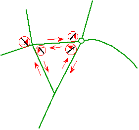
Retains two-way access around the Triangle whilst signalising and widening the Anerley Hill junction to cope better with expected traffic demand. This option would involve widening into the forecourt area of the White Swan pub[Ed.changed name & ownership.Details show no right turn from Westow Hill into Church Rd. and no left turn from Church Rd. into Westow Hill.]
PRO: two way as today
CONS: requies land for widening at Anerley Hill/Crystal Palace Parade junction; few opportunities for parking/loading5. Two-way Triangle, no widening, improve pedestrian crossings
This option was designed to test whether two-way access could be retained around the triangle whilst providing new 'green man' crossing facilities at each junction.[Ed. turn restrictions present at two junctions.]
PROS: two way, without widening at Anerley Hill/Crystal Palace Parade junction; better pedestrian crossing
CONS: heavy traffic congestion; few opportunities for parking/loading6. Westow Hill buses and access only
Buses, cycles, deliveries and residents' vehicles only would be allowed through Westow Hill greatly reducing traffic levels on the street. East-west through traffic would divert to local alternatives or avoid the area altogether.[Ed. tdetails shopw no right turn from Church Rd. into Anerley Hill - no right turn from Church Rd. into Westow St.]
PROS: thrugh traffic removed from Westow Hill
CONS: heavy congestion on other streets in wider area7. Triangle buses and access only
Buses, cycles, deliveries and residents' vehicles only would be allowed to pass through the Triangle, much reducing traffic levels in the Triangle and on Central Hill, Church Road. Large scale re-routing would have a severe traffic impact on the wider area and overall be bad for the environment. Good for buses locally but more delays overall.
PROS: through traffic removed from triangle
CONS: heavy congestion on other streets in wider area
Upper Norwood Triangle
OPTION APPRAISAL - Board 20
The options were tested in the traffic model and scored against the following appraisal framework.
1. Environment:air quality (main vehicle emission gases and particulates).
noise and vehicle intrusion.
land take required
pedestrian space gained or lost
opportunities for visual enhancement.2, Economy:
scheme cost (preliminary estimate)
general traffic journey times
bus journey times (incorporating forecast effect of bus priority)
changes to road network required to accommodate diverting traffic3. Safety and Accessibility:
pedestrian crossings
cycle routes
conditions for parents, elderly and people with disabilities
facilities for deliveries to premises
street parking
convenience of bus stops for destinations
Impact by Area
The options have different effects in different places. Each of the following was considered:
Triangle: Westow Hill/Westow Street/Church Road
Triangle main approaches: Central Hill, Gipsy Hill, Crystal Palace Parade, Anerley Hill, Church Road (south)
Local side roads: Upper Norwood, South Norwood/Anerley, Penge, Gipsy Hill
Study area main roads: A212, A213, A214, A215, A234
Entire modelled area (most of Croydon, Bromley, Lambeth, Southwark, Lewisham)
Option Short List:
It was decided to take forward a one-way and a two-way Option - see following Boards. Following the results of this public consultation further work would be carried out on the preferred option.
ONE-WAY OPTION - Board 21
Traffic Circulation
Parking and Loading
Pedestrians
Buses
Cyclists
Lorries
Upper Norwood Triangle
TWO-WAY OPTION - Board 22
Traffic circulation
Parking and Loading
Lorries
Pedestrians
Buses
Cyclists
TRAFFIC CALMING MEASURES - Board 22
Speed Humps
This type of speed reducing measure is already in use in a number of roads in the area. Humps can be of different heights to suit particular needs. They are not suitable for roads used by buses or as emergency service priority routes.
Speed cushions
Also in use in the area, these are more suited for use on bus routes and emergency service priority routes.
Chicanes
Narrowing the road can limit the speed and volume of traffic. Making traffic in one direction give way to traffic from the opposite direction can further reduce the flow. These are particularly useful near school entrances or areas of high pedestrian activity.
Entry Treatments
Changing the appearance of the entrances to side roads can discourage non-essential traffic from using these roads. Forming a ëgateway' to a residential area can also highlight the change in conditions for drivers.
One way streets and road closures
This is perhaps the most effective means of preventing traffic from entering an area. These measures also affect freedom of access for the residents themselves but in some areas the benefits may be greater than the increased journey times.
Refuges
These are particularly effective on more main roads with higher levels of traffic flow and can reduce speeds and dangerous overtaking manoeuvres. Pedestrians can also be provided with safer crossing locations.
TRAFFIC CALMING - Board 23
Each area can be improved either by removing the traffic from the areas completely or by providing some measures which will make drivers travel slowly and more safely through the area.
Many of the residential roads around the Crystal Palace area already carry more traffic than is necessary to cater for the residents themselves.
As part of the overall improvement of the road network in the area, we want to deal with these problems.
Some of the roads which carry traffic into the area are congested, encouraging traffic to use the residential areas.
On other roads in the area, there are locations which a large number of accidents have occurred.
We would like your views on which of these options will be best for your area.
Traffic Management
ISSUES - Board 25
Traffic calming cannot be considered in isolation from other issues. Reducing traffic levels on some residential roads can increase traffic levels on others or add to congestion. We need to know your preferred options so that we can assess the effects on neighbouring areas. The proposals have been developed after considering:-
Accidents
Some locations are already accident problem sites. We would not want to do anything that would make the problems worse, and we want to use the traffic calming to improve the safety of all the roads in the area.
Cycling
The London Cycle Network includes many of the roads in this area. This is a good opportunity to improve cycling provision in the area.
Buses
Traffic calming has to be designed very carefully on roads used as bus routs. Passenger safety should not be made worse by bumping over road humps or by having sharp deviations to get round build-outs.
Traffic Management
OPTIONS - Board 26
We have divided the whole study area into a number of Traffic Calming Zones and have considered what options may be available for dealing with the traffic. Each zone can be treated differently and there are possible options for each. These are summarised in the diagrams below and shown in more detail in the separate books.
Speed Reduction Measures
One option for dealing with the traffic in each of the zones would be to introduce speed reducing measures in all the roads affected by through traffic,
Preventative Measures
Road closures or one way streets will prevent traffic, at least in one direction, from travelling through a street. They can be very effective but they must be carefully planned to allow access for residents and delivery vehicles.
Please see the traffic calming books for more details.
WHY LOOK AT PARKING CONTROLS - Board 27
Consultants were asked to develop an approach (to parking control) that will restrict commuters and non-essential parking without impinging upon the amenities of residents and other desired groups.
The aims were:
Common Parking Problems
What have we looked at?
WHAT IS CONTROLLED PARKING - Board 28
What will be at the kerb side?
Parking can be managed in a number of different ways at different times of the day, these include:
Resident provision
Residents parking bays are reserved for residents' vehicles displaying parking permits. In order to park at these bays residents will have to buy a permit. Vehicles without a permit would not be allowed to park in these bays during the hours when parking is controlled.
Yellow lines
Yellow lines will be installed where parking is considered to be too dangerous to allow access, the safe movement of traffic or to allow loading and unloading at shops.
Other parking bays
Specially designated parking bays can be provided throughout the area for groups, for example orange-badge holders or local GPs who undertake home calls. In residential areas shared use parking bays could be provided, which could be used by both residents and visitors. Resident permit holder would be able to park (without additional payments) by virtue of their residents' parking permit whilst visitors would be able to park by paying and displaying (as at a metered bay).
Visitor provision
In shopping and station areas metered bays (likely to be controlled by ëpay and display' machines) be provided for short-term (up to a maximum of two hours) and medium-term (up to a maximum of four hours) stay during the hours when parking is controlled.
POSSIBLE LAYOUT - Board 29
Advantages of a CPZ
There are obvious advantages:
Disadvantages of a CPZ
There will of course be a number of disadvantages to different users. These disadvantages include:
ZONING OF CRYSTAL PALACE - Board 30
The Crystal Palace area can be zoned fairly conveniently along the lines shown in the above plan. The zone boundaries have been based on physical divisions such as railway lines and major roads.
Possible sub-zones could be based around the following areas
POSSIBLE TYPES OF PARKING BAY - Board 31 and 32
Maps only.
[The example given was "Gipsy Hill/College", the area bounded by Dulwich Wood Park, Crystal Palace Parade, Salters Hill and Westow Hill. Almost every road is marked blue i.e. a Residents Parking Area. This means parking charges on narrow residential roads during the day until 6 or 8 pm and then free parking for multiplex visitors until they leave at 2 - 3 am.]
OPTIONS FOR DISCUSSION - Board 33
It would take at least two years to introduce a CPZ but consideration needs to be given to the possibilities. At this stage we are not looking for definitive answers but seeking to establish your opinions on the principle of introducing a CPZ. Your input and questionnaire answers will be vital.
Your views are important. Would you like:
We would also like your views on:
NEXT STEPS - Board 34
This exhibition is the first stage in identifying how best to improve transport in the Crystal Palace area. The exhibitions will run until Saturday 5 June but you have until Friday 19 June to return your comments to :
Colin Buchanan and Partners
Newcombe House
45 Notting Hill Gate
London W11 3PB
Your views will be recorded and analysed so that we can identify the options you prefer. A report will then be presented to the Crystal Palace Partnership and to London Transport and to each of the Boroughs. Summary information into will be produced in a future edition of "Update" and will also available from each Borough on request.
The Boroughs and London Transport will use the results of the consultant to define how best to take forward the preferred options. In many cases this will involve further consultation.
Thank you very much for taking part in this very important exercise.
![]()
last update 7/6/99 - minor correctionsand conversation report with Geoff Dadd;7/9/02 telephone no. update